
15 Best Valley of Fire Photography Spots
Teeming with unique sandstone formations, slot canyons, ancient petroglyphs, and precariously balanced rocks, the Valley of Fire photography spots offer endless potential to creative photographers.
As one of the best day trips from Las Vegas, this state park is easily accessible when you have your own rental or as part of a tour so it’s definitely worth adding it to your Las Vegas itinerary.
Before you go, make sure you’re familiar with the best places to take pictures in the Valley of Fire. This way you can maximize your day out and ensure that you visit the spots in a logical fashion.
My guide gives you an overview of the 15 best Valley of Fire Instagram spots you will not want to miss. Let’s get started!
Disclosure: This post contains a few affiliate links, which means I may receive a small commission, at no cost to you, if you make a purchase through my link.

Quick Tips for Valley of Fire State Park
Best Hotels near Valley of Fire State Park
- North Shore Inn at Lake Mead (the closest option with a 10-minute drive to the entrance)
- Moapa Motel (second closest option with a 30-minute drive)
- Eureka Casino Resort (great option in a nearby town, 1-hour drive to the entrance)
best Tours to Valley of Fire State Park
Best Valley of Fire Photography Spots
In order to access the Valley of Fire photo spots, you will need to pay the vehicle fee of $10 (or $15 for non-Nevada vehicles).
The park has two entrances: if you’re coming from the direction of Las Vegas, then you’ll end up at the West Entrance close to the Beehives, while if you’re coming from Lake Mead or staying in the Moapa Valley, you will enter through the East Entrance.
Although the park is open from sunrise to sunset, the ticket booth at the entrance is only open between 9 am and 4 pm. If you’re visiting outside these hours, you need to do self-checking by filling out an envelope and leaving the entrance fee in there. In this case, have cash with you!
Once you’ve paid up, you have access to the entire state park and will not need to pay anything further to visit and take photos of the places listed below.
As a lot of these Valley of Fire Instagram spots are accessible via a hike, you should also consult my guide to the best Valley of Fire hikes while planning your day out.
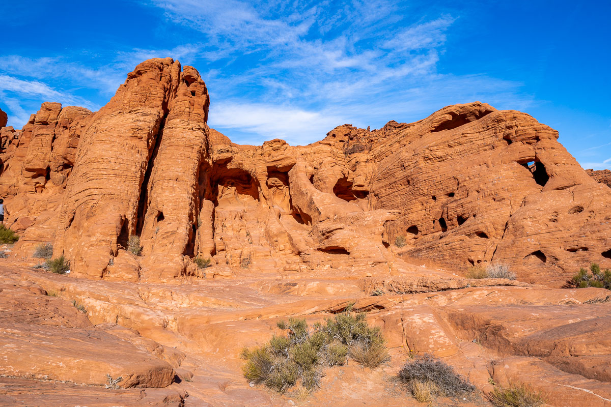
1. Mouse’s Tank Road
Offering a bird’s eye perspective of Mouse’s Tank Road and the surrounding canyons, this is easily one of the best places to take pictures in Valley of Fire – if not the best of all!
There are actually a couple of photo options in this spot where you can get creative with the landscape. Drones are not permitted anywhere in the park so you will need to climb up on top of a huge boulder by the road to get an aerial view. It’s easy to climb up and there is space for you and your photographer on the rock.
Alternatively, you can stand in the middle of the road while your photographer shoots you from the rock with the backdrop of the road and cliffs. The third option is to shoot directly from the middle of the road. Keep an eye out for cars!
Sunrise is the best time in terms of lighting and also to avoid traffic. I know that waking up early is always a struggle, especially if you are coming from Las Vegas, but believe me, it’s so worth it! Seeing the sunrise at Mouse’s Tank Road is definitely one of the best things to do in Valley of Fire State Park.
If you want to find the exact spot where the huge boulder is located, refer to the location I shared below. Otherwise, you might miss it as you will drive north and for the best view, you will need to look to the south!
Location on Google Maps: Mouse’s Tank Road viewpoint


2. Fire Wave
The Fire Wave is a sandstone monument that due to erosion resembles fiery waves rising from the sand and stone. Access is via a short and easy hike that takes you past several other monumental wonders.
Park at the parking lot across the road from the Fire Wave Trailhead on Mouse’s Tank Road. It’s then a 1-hour out and back hike, you will find the Fire Wave waiting for you at the end of the trail.
Once you reach the Fire Wave you can climb on it to take photos or shoot with it in the foreground. This is one of the most unmissable Valley of Fire photography spots and a highlight of the state park for a reason!
The lighting conditions at the Fire Wave are best either at sunrise or sunset. However, if you want to see the vivid colors then it’s best to visit during daylight hours – just avoid hiking during the hottest part of the day.
Location on Google Maps: Fire Wave


3. Pastel (Pink) Canyon
In contrast to the reds and oranges of the Fire Wave, the Pastel (Pink) Canyon is a vision of rose and salmon-hued sandstone rocks.
The canyon is narrow but there is a pathway that weaves you through it and makes it one of the coolest places to take pictures for your feed. You’ll see how erosion has again created a beautiful striped appearance within the pink wonderland.
Pastel Pink Canyon is located right next to Mouse’s Tank Road but there are no parking spots where you can safely pull over, so you have to use the parking lot at the Fire Wave Trailhead.
The easiest way to get to the Pastel (Pink) Canyon is to hike there from the Fire Wave. It only takes a few minutes to extend the hike, follow my advice for the Seven Wonders Loop trail in my Valley of Fire hiking guide before you go.
The photography conditions are best during the daylight but avoid hiking during the hottest part of the day.
Location on Google Maps: Pastel (Pink) Canyon Trail


4. Crazy Hill
Crazy Hill is a stunning rainbow-colored hill that you can visit as part of the Seven Wonders Loop trail. It stands high above the ground and looks like orange, red, pink, yellow, and white paint has been trickled over it.
You can climb right up to the summit for a closer look at the colors. As Crazy Hill is elevated, it is one of the best places to take pictures in Valley of Fire from up high and get a perspective on the landscape of the park.
As with the Pastel (Pink) Canyon, you will get the best conditions during the daytime but plan to hike before or after the hottest part of the day.
Crazy Hill is located on the western side of Mouse’s Tank Road. You can either walk there from the Fire Wave parking lot or turn this into a greater adventure as part of the Seven Wonders Loop trail.
Location on Google Maps: Crazy Hill


5. Slot Canyon on the White Domes Trail
The White Domes Trail is a short yet scenic loop hike that you might recognize from the 1960s Western film, The Professionals.
One of the most stunning Valley of Fire Instagram spots is the slot canyon which you will pass through on the course of this hiking trail. Slot canyons are defined by their length and narrowness with sheer walls that display evidence of erosion. The perfect place to wander with your camera in hand and create some unusual images!
As this hike is popular, tackle it as early as possible for the chance to have the slot canyon to yourself. Leave your car at the White Domes Trail parking lot and complete the 45-minute round hike.
Location on Google Maps: White Domes Trail

6. Rainbow Vista
Rainbow Vista is another Valley of Fire photography location that requires some effort first!
The hiking route is marked by stripey, rainbow-colored boulders which you can climb up for epic views and photo opportunities. The hike is often overlooked in favor of more famous trails so you might be fortunate to see fewer people on this route.
As the hike landscape is exposed to the elements, hike as close to sunset as possible or later in the afternoon.
Park at the Rainbow Vista parking lot on Mouse’s Tank Road and then follow the trail for the 1-mile (1.6 km) out-and-back hike.
Location on Google Maps: Rainbow Vista


7. Fire Canyon/Silica Dome viewpoint
The Fire Canyon/Silica Dome viewpoint is one of the most spectacular Valley of Fire photography locations. The viewpoint is situated on Silica Dome itself, a minor peak, and provides a panorama across the eastern half of the park. On a clear day, you might be able to see Overton and Lake Mead on the horizon.
Silica Dome is composed of pure, almost-white silica (the major constituent of sand) in rock-solid form while the Fire Canyon sweeps off below the viewpoint.
This viewpoint is one of the easiest Valley of Fire photography spots to get to. Just park at the Fire Canyon/Silica Dome viewpoint parking lot on Fire Canyon Road and then walk to the viewpoint in a few minutes.
Views are great whatever time of day you visit. Again, avoid visiting the Fire Canyon/Silica Dome viewpoint under the midday sun as there are no shades.
Location on Google Maps: Fire Canyon/Silica Dome viewpoint

8. Balanced Rock
For those seeking easy photo spots without a massive hike, the Balanced Rock is for you! At the end of the 10-minute trail, you will see a balanced rock that overlooks the craggy orange landscape. Although it is not permitted to climb on the rock, you can capture excellent images from the ground.
As the Balanced Rock is located next to the visitor’s center, it makes sense to visit it first thing in the morning after you pay your park fees.
Location on Google Maps: Balanced Rock

9. Seven Sisters
The Seven Sisters monument comprises seven red, eroded boulders that rise from the sandy desert. They are all that remain from an earlier formation due to natural erosion.
As you get closer you will see dozens of blow holes in the rock which suggests that in the distant future, these rocks will collapse and cease to exist. So act quickly(ish) to see this Valley of Fire photography location before it’s gone.
There is a sheltered picnic area at Seven Sisters and it’s a short walk so you can safely visit at any time of day.
Location on Google Maps: Seven Sisters

10. Elephant Rock
If you love elephants, Elephant Rock is one of the photo spots you shouldn’t miss! As with Balanced Rock, Elephant Rock is fragile, so climbing is not allowed but it’s an awesome place to take photos. As it’s located on a hill, you will also see impressive vistas of the eastern corner of the state park.
With Elephant Rock being positioned in the easternmost perimeter of the park, you might want to make this your final stop of the day and catch the sunset at the landmark before heading back to Vegas.
Park at the Elephant Rock parking lot on the Valley of Fire Highway. Then you can decide between a 10-minute stroll out and back to the monument or a 1.2 mile (1.9 km) hike which provides a deeper investigation into the scenery.
Location on Google Maps: Elephant Rock

11. Greetings from Valley of Fire State Park Sign
If you’re checking out Elephant Rock then you might as well stop for a picture with the Greetings from Valley of Fire State Park Sign!
It’s a cut-out style sign so it’s one of the obvious Valley of Fire Instagram spots for a cute and easy photo to add to your stories. You can shoot here at any time of day, but at busier times you might need to queue while waiting for your turn.
Park at the Elephant Rock parking lot and you’ll see the sign located near the trailhead for the landmark.
Location on Google Maps: Elephant Rock Parking Lot

12. Atlatl Rock
Atlatl Rock is one of the best places to take pictures in the Valley of Fire of the prehistoric petroglyphs that dot the state park and glean insight into the cultural significance of the area.
You will see figures of people and animals as well as other symbols and icons. It was named for an atlatl, a throwing stick that provided greater force when hurling spears and darts.
The rock itself is fitted with a metal staircase so you can access the summit safely and get a closer look at the remains without risking damaging the history.
Park at the Atlatl Rock parking lot and then follow the short trail to the rock. It takes less than 10 minutes and is super easy.
Location on Google Maps: Atlatl Rock


13. Arch Rock
Arch Rock is a small archway that has been formed by strong winds and rains that have weakened over the millennia.
As with the Seven Sisters, this is one of the Valley of Fire photography spots that will eventually dissolve from the scenery. It’s relatively small but beautifully formed and a worthwhile pitstop while you’re in the western corner of the park.
Arch Rock is located on the roadside of an unmarked road off Campground Road. You can pull over in a small parking lot and walk a couple of minutes to see it up close.
As there isn’t much walking involved, you can visit Arch Rock at any time of day but take precautions during the hot afternoon. Also, since the arch is very delicate, climbing on top of it is strictly forbidden.
Location on Google Maps: Arch Rock

14. Fire Cave
The Fire Cave is an incredible cavern of orange and red sandstone that is cut into the canyons just south of the Atlatl Rock Campground. It’s fairly off the radar as most day-trippers are focused on the center of the park and is a wonderful place to take photos.
Lighting conditions are best at this Valley of Fire photography destination either early in the morning or right before sunrise although visiting during the day also works as the sun catches on the caves.
You can pull over on the unmarked road just off the Valley of Fire Highway and you can park directly at the caves.
Location on Google Maps: Fire Cave/Windstone Arch

15. Beehives
The final of my Valley of Fire Instagram spots is located in the western part of the park alongside the past three formations.
Resembling giant beehives, these sandstone crags are a representation of cross-bedding. Grooved lines break off in different directions and show how different layers of silt have been deposited over the millennia.
Even if you’re not so au fait with geology, they’re incredible to see and photograph – especially with soft morning light or right before the golden hour as you leave the park.
Park up at the Beehives parking lot off the Valley of Fire Highway and walk from there – it takes around 10 minutes each way.
Location on Google Maps: Beehive Rock


Best Valley of Fire Photography Spots on the Map
I created a custom map for you that contains all the best Valley of Fire photography spots with their exact location.
Just a quick heads up: most likely you won’t have any cell reception inside the park so make sure to download your maps in advance so you can use them in offline mode!
How to use this map: This map is fully interactive, so you can move around, zoom in/zoom out, and click on the icons. If you want to see a larger map, click on the bracket in the upper right corner. To see more details and the different layers, click on the tab in the upper left corner. If you want to save it for later, click on the star icon next to the name of the map. Then simply open Google Maps either on your desktop or phone, go to ‘Saved’/’Maps’, and open the map whenever you need it.


Hello! Do you need a photo permit for all of these locations if you’re taking elopement styled photos for someone? Thanks!
Hi! I don’t think you need any special permits but I’m not sure. It might be best to contact the park and ask them about it!